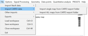
3. In dialog menu, navigate to the folder with CARTO export. Folder should contain file or files with geometry (with .mesh extension), file with a list of data points (with .car extension) and several files with electrograms recorded at each data point (with _ECG_Export.txt extensions).
4. [if selecting single map import] Dialog window with a list of geometries will appear. Select geometry you want to import and click ok.
5. Import may take a moment depending on export size.
6. At the end of export, app will ask whether to center geometry. If only one map is to be analysed, click Yes. If you plan to superimpose several maps, click No.
7. By default, CARTO exports original data point xyz coordinates, which may be inside the chamber. To project them onto surface, go to menu: